Holland Homes and Business’s Taken and Flooded by the Government; the Flood of 1955.
As we remember the 55 Flood I thought I’d post some pictures and add some recollections.
Late in the evening of August 19th 1955, the Holland Dam broke which was both a horrible and tragic event.
Horrible because of the devastation it caused to many of our Holland residents who lived in the area of Lake Siog, and tragic for the ramifications it would have on the removal of an entire way of life from that section of our town as the shores along lake Siog were home to so many.
I only have a couple of recollections about the flood; I was only three and a half years old or so. One is of my father standing with me on one side of the bridge that was washed out looking toward Holland and my uncle Pickles (George Hickland) on the other, yelling over to my father about what had just happened. The other is my dad getting water out of the shallow well as the power had gone out.
One of our town residents who does remember that night is Robbie Piazzo who not only lived in Holland his entire life up until then and for many years thereafter, but was also born at his family’s homestead on 5 Bridge Road.
The historic black and white pictures published here were given to me by Mr. Piazzo in hopes of preserving some of the history about the 55 flood in Holland, but also to preserve the memories about some of the establishments and culture that existed back then in that section of town.
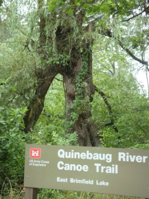
Pictured above:
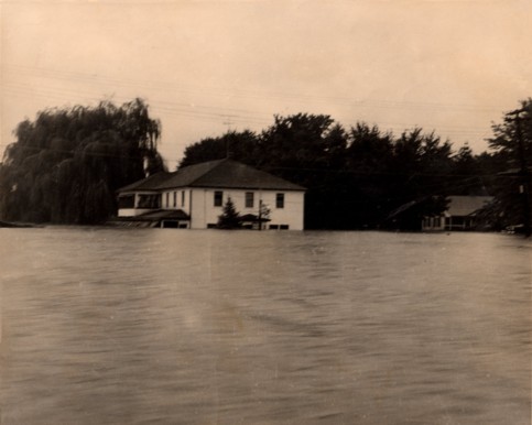
The Anchor immediately after the peak of the 55 flood. Please note the willow tree in the back of the Anchor and to the left in the picture.
The tree was planted by Robbie’s father Casimiro Piazzo.
The tree is still there today and shown in the picture on the left. The tree was snapped in half during a storm.
Click on any picture to download a larger image!
The picture below shows the Willow tree and the bridge to illustrate the location of the removed structure that was “The Anchor” Restaurant and Inn.
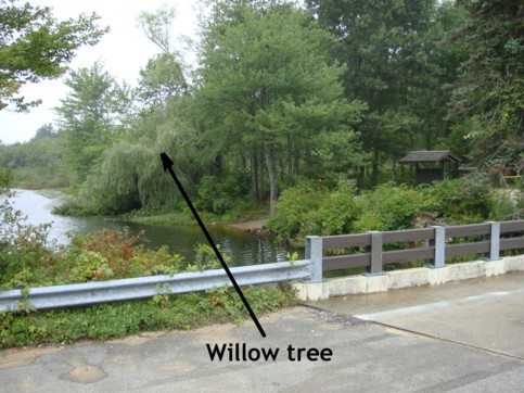
The bridge of which you can see one side to the right in the above picture was built in 1972 by the US Army Corps of Engineers to replace the bridge built by Casimiro Piazzo in the same location. The reader may notice the railing of the original bridge Shown on the left in the picture below.
Please also note again the same Willow Tree behind the Anchor.
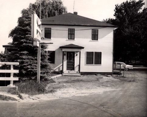
Pictured above, the Anchor after the flood. The picture was taken during the discussions whether it should be taken down by the Federal Government, which took place about 1956 or 1957.
The Anchor, which was also known by some as “La Hotel Piazza” was built by Robbie’s father, Casimiro Piazzo, about 1934.
The Anchor was located just where the turnaround and parking area is in the corner east of the bridge and north of Pond Bridge Road, in-between the Quinebaug River and what use to be Cross Road to the right (east) of the Anchor where the white car is parked (see picture above).
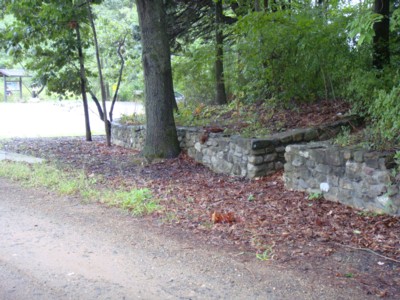 The steps up to the entrance of the house to the east of the Anchor shown on the right side of the first picture are still there to this day and shown in the picture on the right. The house was home to the Bagley family.
Cross Road was merging into Pond Bridge Road and was in-between the Anchor and the house shown in the first photograph.
I asked Robbie if there were any warnings by Town or State Officials, during that night before the dam broke, and if there had been any predetermined warning signals worked out to alert the residents and town’s people in the area downstream in the event the dam were to break.
He said there wasn’t.
He recalled that when he and his family went to bed that night, the water from the Quinebaug River had reached the level of the parking lot.
They had pumps going in the basement in an attempt to keep out the water but they eventually failed.
They moved as much of the liquor, food, and valuable things from the bar and restaurant as they could to the second floor before he and his family turned in for the night.
He said there was no warning, no noise, and they awoke the next morning to find the water up to the second level of the Restaurant and Hotel. That night the water level just quietly rose after the dam broke. He, his wife Connie, and his two children David and Robin had to be taken out by boat the next day.
He recalled that it had rained for days and days and that the sound of the water running off the hills and mountains sounded like a train coming through.
He said despite the water rising up so high that in the end they didn’t have as much damage to the Anchor as one would expect and that they were ready to open again for business by Thanksgiving’s day of 1955 and continued to operate until 1958, when they were forced to let go of the property.
The Anchor was subsequently taken by Eminent Domain for the Flood Control Project.
That project claimed over 2500 acres in our immediate area. There has been a lot written about the 55 flood but it seems Holland usually is left out of most of the reports. Towns like Sturbridge, Southbridge, and towns beyond are usually covered in reports because they were so much bigger and so much damage was done to them. But the fact remains that the town of Holland and a large number of its residents in the end sacrificed their homes, their businesses, and their way of life for what was to be the progress in form of the Flood Control Project that was carried out by the Us Army Corps of Engineers to benefit the communities downstream.
The town of Holland lost one of its most beautiful sections and some people say that it didn’t have to happen the way it did. I doubt that this would and could happen today. There would be a public outcry if the government came in and tried to take an entire section of our town and the entire village of East Brimfield like they did back then.
Robbie, others, and I, find it puzzling as to why so little is written about Holland in association with the 55 disaster. Holland was such a big part of it.
Things might have ended up much differently had the dam not let go that night.
A lot of residents are unaware of the fact that the town of Holland had another Hotel and Restaurant besides the Holland Inn, “The Anchor.”
I hope the readers enjoy Robbie Piazzo’s historic photographs about the 55 flood and “The Anchor,” the forgotten Restaurant and Hotel Robbie’s family operated for so many years before it fell victim to the Flood Control Project. Much like the Holland Inn it was a place for area residents to congregate and socialize.
Shown in the next picture is the house that sat opposite Cross Road where the Anchor was located and which now has a gate across where it abuts the parking lot that now exists. The house belonged to the Bagley’s.
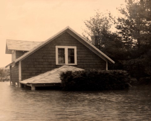
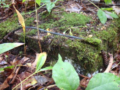 The picture on the left shows part of the foundation of the house pictured above. Considering the size and location of the slab, it could have been the base of the chimney visible in the picture above. There are also some electric wires with the old fashion aluminum sleeve visible.
The next picture shows three houses and two other structures floating in lake Siog. They use to be on the small point that people can only walk out to since the River Road has been closed.
They were built on piers which resulted in them pulling away and floating out into the lake.
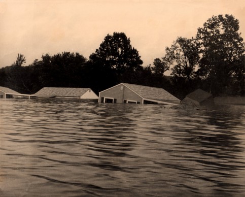
Shown in the next picture is Alberta and Bryant Gardner’s submerged house with only the rooftop showing. It is one of the houses that sat along the east shore of lake Siog.
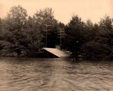
Alberta and Bryant Gardner’s house was a beautiful contemporary house. It was later disassembled and moved to West Brookfield by Reno Piazzo where it still stands today.
Reno Piazzo, the brother of Robbie Piazzo, also lost a business. He owned and operated a super market at the intersection of Pond Bridge Road, Old East Brimfield Road, and River Road.
There is a cement pad that served as the foundation where this house stood that is still there to this day. People have picnics and fish from the pad without realizing that they are having their picnic or lunch in, what was once not only the living room of the Gardner family but one of the nicest homes in Holland during those times.
It was said that Mrs. Gardner was heartbroken immediately following the flood. Spectators operating power boats before the water had receded created waves that went right through the house. Her china and crystal was falling off her shelves from the waves and breaking.
Brian Gardner was one of the selectman back then and as such, he orchestrated the negotiations between the government and the home owners of houses that were removed for the Flood Control Project. The Gardners moved out of town shortly thereafter.
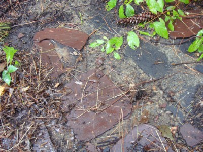
To this day, you can see the remains of the driveways, walls, and concrete slabs, where the Gardner houses use to be.
Although it gets harder each year to find them, once in a while you can walk through what was once someone’s yard in the spring and summer and you’ll find the flowers that were once the border of someone’s sidewalk or flower garden that still come up every year to reward the people that planted them and lived there so long ago even though they have been gone nearly 55 years.
There’s still a lot of the people that lived in that section of town that are still nearby, and I wonder sometimes how many go back to walk around their old yard or to visit what, in their hearts, will always be "Home".
If anyone has any stories about the 55 Flood I know Peter would appreciate them being posted to the Holland Blog.
Here are links with more pictures and reports about the 1955 Flood.
Whitney Web Page - Southbridge History Flood of 1955The Flood of 1955 by James J. LeBlanc, Jr.
The Connecticut Floods of 1955: A Fifty-Year Perspective

Leslie & Gerry Germaine
Hisgen House Bed & Breakfast
78 Hisgen Road
Holland, Massachusetts 01521
Tel 413 245 6267
or 508 347 6300